Browse Items (79 items total)
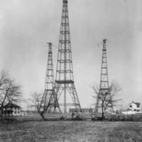
In 1913 the Navy erected three huge radio towers at the intersection of Columbia Pike and Courthouse Road, between the two African American communities of Johnson's Hill and Butler-Holmes. These radio towers, called the “three sisters,” were marvels of modern communications technology and engineering in their time. They were the tallest man-made structures in the world upon their completion in 1913, towering over local pillar the Washington Monument. In 1915 they transmitted the first trans-Atlantic voice communication to the Eiffel Tower.
The towers were removed in 1941 because they obstructed flight-paths for the newly constructed Washington National Airport.
The towers were removed in 1941 because they obstructed flight-paths for the newly constructed Washington National Airport.
Collection: Neighborhoods
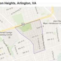
Arlington Heights is a neighborhood bounded by Arlington Boulevard, South Fillmore Street, South Walter Reed Drive, Columbia Pike, and South Glebe Road. The area that would become Arlington Heights began in the early 1900s with the construction of 28 Craftsman-style Bungalow homes. These homes were located across 25 discreet subdivisions which came together to form Arlington Heights. From 1936 to 1942 construction surged in Arlington Heights with numerous brick Colonial Revival-style homes and a garden-style apartment being constructed within the neighborhood. The neighborhood also features one high-rise apartment building, a commercial building, a synagogue, a parsonage, a middle school with community center and two landscaped parks. The last major construction projects were completed in 1978. Arlington Heights was put on the National Register of Historic Places in 2008.
Collection: Neighborhoods
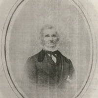
Bazil Hall is the namesake of the Hall's Hill community. Hall moved from Washington, D.C. in 1852 to Arlington where he purchased 327 acres of land to farm. During the Civil War his home and land were damaged first by a skirmish between Union and Confederate forces and then by a Union encampment on his property. Before the war Hall's estate was valued at $25,000, but following the war it was valued at only $6,4000. Despite deep seated prejudices, Hall decided to sell his land to formerly enslaved African Americans following the war in order to stay afloat. This led to the creation to the Hall's Hill community, today called High View Park.
Collection: Neighborhoods
The community of Hall's Hill, today called High View Park, was established in 1865 when white land-owner Bazil Hall, hit with hard-times following the Civil War, sold lots of his land to formerly enslaved African Americans. From these beginnings Hall's Hill became a thriving black community.
Local community institutions of note include Glebe Elementary School, Langston Brown Community Center, Calloway United Methodist Church, and Fire Station #8, Arlington's first African American fire company. Hall's Hill is one of the few remaining African American neighborhoods in Arlington. During the mid-twentieth century, the bordering white community built a cinder-block wall around Hall's Hill to physical separate themselves from their black neighbors during formal, legalized residential segregation. Pieces of that wall remain.
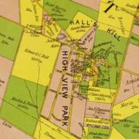
The community is bounded North by Lee Highway, East by Glebe Road, South by 17th Street North, and West by George Mason Drive. This map shows the growing community in 1900.
Local community institutions of note include Glebe Elementary School, Langston Brown Community Center, Calloway United Methodist Church, and Fire Station #8, Arlington's first African American fire company. Hall's Hill is one of the few remaining African American neighborhoods in Arlington. During the mid-twentieth century, the bordering white community built a cinder-block wall around Hall's Hill to physical separate themselves from their black neighbors during formal, legalized residential segregation. Pieces of that wall remain.
The community is bounded North by Lee Highway, East by Glebe Road, South by 17th Street North, and West by George Mason Drive. This map shows the growing community in 1900.
Collection: Neighborhoods
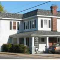
At Hunter Station the Fort Myer Branch of the Washington, Alexandria, and Falls Church commuter rail line met with trolley car lines. Hunter Station was located within the African American Butler-Holmes community, today called Penrose. With connections to Rosslyn, Georgetown, and downtown Washington, these lines helped to expand Butler-Holmes throughout the early twentieth century. The community was also served by the Columbia Station near present-day Columbia Pike and Walter Reed Drive, but the station's exact location is not known. Today Hunter Station is a private residence.
Collection: Neighborhoods
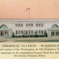
Rosslyn was a main commuter core for each of Arlington's trolley lines. The station connected lines from Virginia and the District in addition to serving as a hub for foot and bus traffic. These images show the inside (postcard) and outside (photograph) of the Rosslyn Terminal Station. The station was built by the Washington and Old Dominion railroad in 1923 when the line discontinued its service into Washington after eleven years. It remained in use until 1939, when the government acquired the land as part of the George Washington Memorial Parkway National Park site.
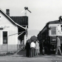
This image shows East Falls Church Station on May 31, 1951, the last day of passenger service. This stop was originally opened as a part of the Washington, Arlington & Falls Church line in 1901 and became a part of the Washington-Virginia Railroad in 1913. The line had been in financial trouble since the 1920s as commuters increasingly turned to automobiles for travel. After a brief resurgence in use and support during World War Two, the line finally ended its passenger service in 1951.
Collection: Neighborhoods
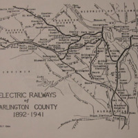
This map shows each of the electric railways lines and stops within Arlington County from 1892 through 1941. It helps to show the increased connectivity of county residents to Washington and within the county. Trolley growth helped to encourage continued suburbanization and community development throughout Arlington in the late nineteenth and early twentieth centuries.
By 1924 Arlington's electric railway lines provided 64 stops within the County, 28 stops to destinations further north, 7 southern stops which connected to Alexandria.
By 1924 Arlington's electric railway lines provided 64 stops within the County, 28 stops to destinations further north, 7 southern stops which connected to Alexandria.
Collection: Maps
The Washington-Virginia line was formed by a merger of the Washington, Alexandria, and Mt Vernon and the Washington Alexandria and Mt Vernon railroads.
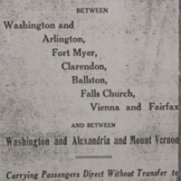
This advertisement for the Washington-Virginia Railway highlights the lines' many connections to the neighborhoods of Arlington and downtown Washington, D.C. The advertisement boasts how the new line is "within a few minutes walk to all Theatres, Government Buildings, Department Stores," and more. This list of attractions highlights the social, cultural, and employment amenities available to Arlington residents with the expansion and opening of the trolley lines during the early twentieth century. With this increased connection to D.C. and the desire to live within suburban, single family homes the "Fort Myer, Clarendon, Ballston, and Falls Church" communities and more all continued to grow.
This advertisement for the Washington-Virginia Railway highlights the lines' many connections to the neighborhoods of Arlington and downtown Washington, D.C. The advertisement boasts how the new line is "within a few minutes walk to all Theatres, Government Buildings, Department Stores," and more. This list of attractions highlights the social, cultural, and employment amenities available to Arlington residents with the expansion and opening of the trolley lines during the early twentieth century. With this increased connection to D.C. and the desire to live within suburban, single family homes the "Fort Myer, Clarendon, Ballston, and Falls Church" communities and more all continued to grow.
Collection: Neighborhoods
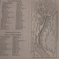
This pamphlet from the Washington and Old Dominion (W&OD) railroad company features a map and station list for their services. Trolley service in the late-nineteenth and early-twentieth centuries helped to expand and encourage suburban development in Arlington. The company advertises its Bluemont and Great Falls divisions, which service such Arlington neighborhoods as Rosslyn, Glencarlyn, Barcroft, and Alexandria Junciton.
Collection: Maps